
Resources for Wisconsin Land Trusts
Legal Services
The Land Conservation Law Program is an innovative program with two main objectives: to provide legal services directly to Wisconsin land trusts, and to deliver education and training to attorneys across the state in order to broaden a community of legal practice available to support land trusts and land owners in land conservation transactions.
By convening a Land Conservation Law Advisory Council to guide the service offerings and development of educational materials, the Program brings a broad range of experience and expertise to the benefit of Wisconsin’s land trusts.
The services provided by the Program are intended to supplement, not supplant, existing relationships lands trusts may have with legal counsel, and offer Wisconsin land trusts a more accessible and cost effective means of addressing questions as they arise.
A Land Conservation Law Program staff attorney is available to land trusts to answer general questions about conservation transactions and land trust operations through a subscription-based hotline, and also to provide a menu of legal services—such as easement drafting and title review—on an hourly basis.

If you have questions about the Land Conservation Law Program, please reach out to Chris Gutschenritter, Director of Land Conservation Law Program, at 608-251-9131 x17 or chris@gatheringwaters.org
GIS Services
Gathering Waters is proud to provide a comprehensive geodatabase of land trust protected areas in Wisconsin.
The geodatabase is only available to our land trust members.
How to Access the Data
Available to Gathering Waters member land trusts, access the tool at this link if you access ArcGis Online through Gathering Waters. If you are a member of your own organization’s ArcGis Online space, access the tool through the “Land Trust Member Files” group hosted by Gathering Waters. Email Charlie if you need access to either space. For more information, read this blog article.
The above links may change from time to time. Check back here for updated links and new offerings.
- If you have an organizational (paid) ArcGis subscription, email Charlie with your user id.
- No ArcGIS account? No problem. If you do not have an ArcGis account, get in touch with us and we can get you set up.
Are you a researcher or affiliated with a partner organization and need access to the land trust geodatabase for your work? We are able to make a version of the land trust geodatabase available to researchers and partners on a case by case basis with some restrictions on use. Please contact us for details.
Interactive Web Map
The interactive viewer provides easy access to land trust holdings as well as other data that land trusts often use including: DNR protected areas; the statewide parcel database; and Important Bird Areas. We welcome suggestions on other data to include in this viewer or other interactive tools you would like to see offered by Gathering Waters. Please note, the viewer is designed to be used on a full-screen web browser. We’re working on mobile-friendly versions.
GIS Feature Service
This provides access to the GIS data itself, which you may work with in your ESRI GIS software of choice. Please note, you'll need to be logged in to an ArcGIS account that has been granted access in order to use the data.
Using this feature service instead of static shapefiles will ensure that you are always accessing the most up-to-date version of the land trust geodatabase.
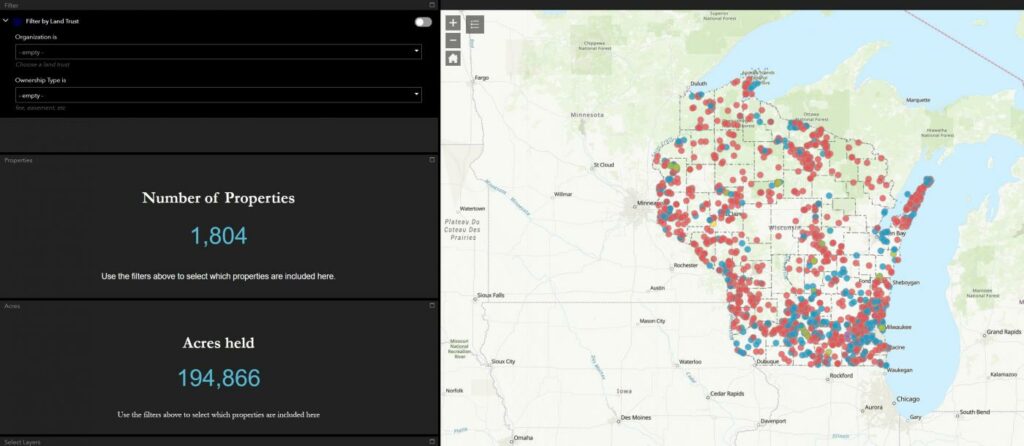
GIS Decision Support Tool
Version 2 is live! The tool is intended to aid conservation planning efforts by putting a tremendous amount of data at land trusts’ fingertips as well as robust filtering capabilities to quickly zero in on particular geographies and conservation priorities.
Please see see this help document for details on all the new features included in version 2. Version 1 is still available here.
Legislative Districts & Land Trust Properties App
2024 redistricting brought major changes to Wisconsin's political geography.
Use this app to compare the old and new legislative districts and to quickly see which land trust properties lie within a given senate or assembly district.

If you have questions about our GIS Services, please reach out to Charles Carlin, Director of Strategic Initiatives, at 608-251-9131 x15 or charles@gatheringwaters.org
Gathering Waters serves member land trusts across the state. To become a member, or for more information, please contact us.
